
About 25 miles east of Billings, Montana,
one of the most famous sandstone buttes
overlooks the Yellowstone River.


This is Pompey's Pillar, so named
in honor of Sacagawea's son,
Jean Baptiste Charbonneau,
whom Captain William Clark of Lewis and Clark Expedition fame,
had nicknamed "Pomp."
The pillar covers about 2 acres at its base
and stands about 150 feet high.
It is the only sandstone outcrop
on the Yellowstone River for several miles
in either direction
and has been a landmark for centuries.
A boardwalk leads to the top of the pillar
and to Captain Clark's signature,
which he engraved in the sandstone.
 First, we checked out the visitor's center.
 Bust of Captain William Clark.
 The Pillar is in the heart of Crow country and is a sacred site for many American Indians. Crow legend tells us that the Pillar was formed by the Supreme Power who broke it free from the northern cliffs and rolled it across the river. Crow Indians (also known as the Apsaalooke) have visited the Pillar for centuries to pray and seek guidance through vision quests - a ritual of fasting and praying.
The mountain lion is sacred to the Apsaalooke. According to tradition, this fierce predator visited an Indian while he was fasting at the Pillar, but did not harm him. From that time the Crow people have respected the site as the dwelling of the mountain lion.
A voice from a cloud once declared, "Any Apsaalooke (Crow) who fasts at Where the Mountain Lion Lays will lead you to prosperity."
The Pillar is in the heart of Crow country and is a sacred site for many American Indians. Crow legend tells us that the Pillar was formed by the Supreme Power who broke it free from the northern cliffs and rolled it across the river. Crow Indians (also known as the Apsaalooke) have visited the Pillar for centuries to pray and seek guidance through vision quests - a ritual of fasting and praying.
The mountain lion is sacred to the Apsaalooke. According to tradition, this fierce predator visited an Indian while he was fasting at the Pillar, but did not harm him. From that time the Crow people have respected the site as the dwelling of the mountain lion.
A voice from a cloud once declared, "Any Apsaalooke (Crow) who fasts at Where the Mountain Lion Lays will lead you to prosperity."
 York
William Clark's Slave
Born Around 1770
Virginia
As clark's slave, York was expected to serve his master on the long and treacherous journey. Despite his servitude, York was often treated as an equal by the Corps. American law in the early 1800's prohibited slaves from using firearms and from voting. York carried a flintlock rifle and shot deer, buffalo, antelope, and elk. When it came to making imporant decisions, York, on at least one occasion, voted as an equal member of the Corps.
Indian tribes were in awe of York's dark skin and 6 foot, 200 pound stature. They were unsure whether he was a man, a beast, or a spirit-being.
York
William Clark's Slave
Born Around 1770
Virginia
As clark's slave, York was expected to serve his master on the long and treacherous journey. Despite his servitude, York was often treated as an equal by the Corps. American law in the early 1800's prohibited slaves from using firearms and from voting. York carried a flintlock rifle and shot deer, buffalo, antelope, and elk. When it came to making imporant decisions, York, on at least one occasion, voted as an equal member of the Corps.
Indian tribes were in awe of York's dark skin and 6 foot, 200 pound stature. They were unsure whether he was a man, a beast, or a spirit-being.

 William Clark
Expedition Co-leader, Negotiator, Engineer, Geographer, Frontiersman
Born August 1, 1779
Caroline County, Virginia
William Clark was a frontier child. He rode horses, surveyed land, hunted, and helped manage his family's estate. At 19 he joined the army. Years later President Jefferson asked Meriwether Lewis, an officer who had served under Clark's command, to lead an exploration into the American West. Lewis in turn invited Clark to co-captain this unprecedented journey.
Clark could not refuse Lewis' bold request, and the two began planning their voyage.
William Clark was a skilled leader and meticulous writer. His journal entries and sketches provide many of the details about the trip. As the expedition's cartographer, Clark drew a radically new map of the West. The maps we use today evolved from Clark's drawings and measurements of these fabled lands.
William Clark
Expedition Co-leader, Negotiator, Engineer, Geographer, Frontiersman
Born August 1, 1779
Caroline County, Virginia
William Clark was a frontier child. He rode horses, surveyed land, hunted, and helped manage his family's estate. At 19 he joined the army. Years later President Jefferson asked Meriwether Lewis, an officer who had served under Clark's command, to lead an exploration into the American West. Lewis in turn invited Clark to co-captain this unprecedented journey.
Clark could not refuse Lewis' bold request, and the two began planning their voyage.
William Clark was a skilled leader and meticulous writer. His journal entries and sketches provide many of the details about the trip. As the expedition's cartographer, Clark drew a radically new map of the West. The maps we use today evolved from Clark's drawings and measurements of these fabled lands.


 Sacajawea
Indian Interpreter and Guide
Born around 1788
Born: Rocky Mountains in Present Day Idaho
At 12 years old Sacagawea was kidnapped by Hidatsa Indians and taken from her Shoshone
tribe's home in the Rocky Mountains to a village on the upper Missouri. There, she and another captive girl were purchased as "wives" by Toussaint Charbonneau, a French-Canadian trapper.
In 1804 Sacagawea and Charbonneau joined the Corps of Discovery. Sacagawea's knowledge of the Shoshone and Hidatsa languages helped the explorers communicate and establish trusting relationships with American Indians.
Sacajawea may have also been perceived as a symbol of peace. "The sight of This Indian woman, ... confirmed those people of our friendly intentions, as no woman ever accompanies a war party of Indians in this quarter," Clark wrote on October 19, 1805.
Jean Baptiste Charbonneau
Infant Explorer
Born February 11, 1805
Fort Mandan
The son of Touissant Charbonneau and Sacagawea, Jean Baptiste Charbonneau was an adventuresome infant, but not by choice. His parents were serving as guides and interpreters for the expedition, so Jean Baptiste spent the first year and a half of his life traversing the West as the youngest member of the corps of Discovery. Clark doted on the child who was nicknamed "Pomp."
Arriving at an extraordinary sandstone outcropping along the Yellowstone River, Clark named the formation Pompy's Tower in honor of his young companion.
Sacajawea
Indian Interpreter and Guide
Born around 1788
Born: Rocky Mountains in Present Day Idaho
At 12 years old Sacagawea was kidnapped by Hidatsa Indians and taken from her Shoshone
tribe's home in the Rocky Mountains to a village on the upper Missouri. There, she and another captive girl were purchased as "wives" by Toussaint Charbonneau, a French-Canadian trapper.
In 1804 Sacagawea and Charbonneau joined the Corps of Discovery. Sacagawea's knowledge of the Shoshone and Hidatsa languages helped the explorers communicate and establish trusting relationships with American Indians.
Sacajawea may have also been perceived as a symbol of peace. "The sight of This Indian woman, ... confirmed those people of our friendly intentions, as no woman ever accompanies a war party of Indians in this quarter," Clark wrote on October 19, 1805.
Jean Baptiste Charbonneau
Infant Explorer
Born February 11, 1805
Fort Mandan
The son of Touissant Charbonneau and Sacagawea, Jean Baptiste Charbonneau was an adventuresome infant, but not by choice. His parents were serving as guides and interpreters for the expedition, so Jean Baptiste spent the first year and a half of his life traversing the West as the youngest member of the corps of Discovery. Clark doted on the child who was nicknamed "Pomp."
Arriving at an extraordinary sandstone outcropping along the Yellowstone River, Clark named the formation Pompy's Tower in honor of his young companion.
 Bullboat used by the explorers.
 Letter from Jefferson to Lewis, October 10, 1806:
"I received, my dear sir, with unspeakable joy,
your letter of Sept. 23 announcing the return of yourself, Capt. Clark, and your party in good health to St. Louis. The unknown scenes in which you were engaged, and the length of time without hearing of you had begun to be felt awful."
Toast given to Lewis and Clark on September 24, 1806
at Christy's Tavern in St. Louis:
Captains Lewis and Clark - their perilous services endear them to every American heart."
Letter from Jefferson to Lewis, October 10, 1806:
"I received, my dear sir, with unspeakable joy,
your letter of Sept. 23 announcing the return of yourself, Capt. Clark, and your party in good health to St. Louis. The unknown scenes in which you were engaged, and the length of time without hearing of you had begun to be felt awful."
Toast given to Lewis and Clark on September 24, 1806
at Christy's Tavern in St. Louis:
Captains Lewis and Clark - their perilous services endear them to every American heart."
 We indulge not in the delusions of hope, nor the visions of fancy; when we behold in this expedition ... the germ of extended civilization, science and liberty ..."
Spokesman at Reception for Meriwether Lewis in Charlottesville, Virginia
We indulge not in the delusions of hope, nor the visions of fancy; when we behold in this expedition ... the germ of extended civilization, science and liberty ..."
Spokesman at Reception for Meriwether Lewis in Charlottesville, Virginia

 The Route West
In search of an all-water route between St. Louis and the Pacific Ocean,
the Corps of Discovery journeyed west across miles of treacherous terrain and unexpected mountain ranges.
The Route West
In search of an all-water route between St. Louis and the Pacific Ocean,
the Corps of Discovery journeyed west across miles of treacherous terrain and unexpected mountain ranges.
 Clark's Return Route
On their return home Lewis and Clark separated between July 3rd and August 12, 1806. Captain Clark and his party explored the Yellowstone River.
Clark's Return Route
On their return home Lewis and Clark separated between July 3rd and August 12, 1806. Captain Clark and his party explored the Yellowstone River.
 Lewis's Return Route
At Traveler's Rest in present day Montana,
Lewis headed north to explore the Marias River
before continuing down the Missouri River.
Lewis's Return Route
At Traveler's Rest in present day Montana,
Lewis headed north to explore the Marias River
before continuing down the Missouri River.
 Ordway's Return Route
On July 13th, 1806, Sergeant Ordway departed from Clark's group along with nine corps members and six canoes that had been left the previous summer. They traveled down the Missouri River and met up with Lewis.
Ordway's Return Route
On July 13th, 1806, Sergeant Ordway departed from Clark's group along with nine corps members and six canoes that had been left the previous summer. They traveled down the Missouri River and met up with Lewis.
 Pryor's Return Route
Sergeant Pryor separated from Clark's party on July 23rd with instructions to trade the remaining horses with the Mandan people for for supplies. Pryor lost the horses, but his group reunited with Clark's on August 8th.
Pryor's Return Route
Sergeant Pryor separated from Clark's party on July 23rd with instructions to trade the remaining horses with the Mandan people for for supplies. Pryor lost the horses, but his group reunited with Clark's on August 8th.
 This is a replica of Capt Clark's signature.
The actual signature on Pompey's Pillar is the only
remaining physical evidence of the Lewis and Clark Expedition.
This is a replica of Capt Clark's signature.
The actual signature on Pompey's Pillar is the only
remaining physical evidence of the Lewis and Clark Expedition.
"... At 4 PM [I] arived at a remarkable rock
Situated in an extensive bottom...
This rock which I shall Call Pompy's Tower is
200 feet high and 400 paces in
secumphrance... The natives have ingraved
on the face of this rock the figures of animals &c,
near which I marked my name and the day of the month & year."
-William Clark. July 25, 1806
Clark named the outcrop Pompy's Tower
after Scajawea's son, whom he nicknamed Pompy.
Pomp means "little chief" in the Shoshoni language.
It was renamed Pompey's Pillar in 1814
when the Lewis and Clark journals were published.
 Pompey's Pillar
National Historic Landmark
Dedicated to the vision and spirit of the individuals
who passed this way and left an indelible mark on
the history of this great nation.
Held in trust by the U.S. Department of the Interior
Bureau of Land Management for those who follow.
July 23, 1992
Pompey's Pillar
National Historic Landmark
Dedicated to the vision and spirit of the individuals
who passed this way and left an indelible mark on
the history of this great nation.
Held in trust by the U.S. Department of the Interior
Bureau of Land Management for those who follow.
July 23, 1992
 Hundreds of markings and inscriptions
have been left by visitors to Pompey's Pillar,
transforming this geological phenomenon into a living journal
of the American West.
Archeological evidence indicates that the Pillar
was a place of ritual and religious activity.
Hundred of petroglyphs on the face of the rock reflect
the importance of the monument to early peoples.
In his journal, Clark noted evidence of Native American presence,
The Indians have made 2 piles of Stone on top
of this tower.
The natives have ingraved on the
face of this rock the figures of animals....
The presence of aboriginal rock art
is indicative of ritual behavior.
The placement of prehistoric rock art in the Norther Plains
is not random.
The places where rock art occurs were of great importance
to the ancient artists.
Pictographs and petroglyphs have been found on the Pillar.
Hundreds of markings and inscriptions
have been left by visitors to Pompey's Pillar,
transforming this geological phenomenon into a living journal
of the American West.
Archeological evidence indicates that the Pillar
was a place of ritual and religious activity.
Hundred of petroglyphs on the face of the rock reflect
the importance of the monument to early peoples.
In his journal, Clark noted evidence of Native American presence,
The Indians have made 2 piles of Stone on top
of this tower.
The natives have ingraved on the
face of this rock the figures of animals....
The presence of aboriginal rock art
is indicative of ritual behavior.
The placement of prehistoric rock art in the Norther Plains
is not random.
The places where rock art occurs were of great importance
to the ancient artists.
Pictographs and petroglyphs have been found on the Pillar.

 "The natives have ingraved on the face of this rock the figures of animals &c near which I marked my name and the day of the month & the year.
-Lewis & Clark Journals July 25, 1806
The ground on which Clark stood has weathered away
but his signature has not.
Because of this remaining physical evidence,
the site is one of the few places along the entire
Lewis and Clark Trail where you can be assured
of standing in the footsteps of William Clark
and other members of the Expedition.
"The natives have ingraved on the face of this rock the figures of animals &c near which I marked my name and the day of the month & the year.
-Lewis & Clark Journals July 25, 1806
The ground on which Clark stood has weathered away
but his signature has not.
Because of this remaining physical evidence,
the site is one of the few places along the entire
Lewis and Clark Trail where you can be assured
of standing in the footsteps of William Clark
and other members of the Expedition.

 Clark marked his presence by engraving his name and the date of his visit
on the outcrop. This simple inscription is the only remaining on-site
physical evidence of Lewis and Clark's epic journey.
Clark arrived here on his return trip from the Pacific coast.
His journal recorded his stop at this "remarkable rock" with its
"extensive view in every direction."
He described an idyllic landscape of grassy plains,
snow-capped mountains, and cliffs abutting the wandering river.
Later on, trappers, soldiers, and others looking for adventure
and a new way of life used the Lewis and Clark journals for directions
and Pompey's Pillar as a landmark.
Clark marked his presence by engraving his name and the date of his visit
on the outcrop. This simple inscription is the only remaining on-site
physical evidence of Lewis and Clark's epic journey.
Clark arrived here on his return trip from the Pacific coast.
His journal recorded his stop at this "remarkable rock" with its
"extensive view in every direction."
He described an idyllic landscape of grassy plains,
snow-capped mountains, and cliffs abutting the wandering river.
Later on, trappers, soldiers, and others looking for adventure
and a new way of life used the Lewis and Clark journals for directions
and Pompey's Pillar as a landmark.
 Pompey's Pillar
Discovered and named by Captain William Clark of the
Lewis and Clark Expedition
June 25, 1808
Clark returning down the Yellowstone
with Pryor Shannon Bratton Windsor
Hall Shields Gibbon Labiche
Charboneau Sacajawea and Child
York the slave
In gratitude to Lewis and Clark,
intrepid leaders, to Sacajawea, their
unerring guide, and to the fidelity
and courage of all the company.
This tablet is dedicated by
Shining Mountain Chapter
Daughters of the American Revolution
Billings Montana
May 24, 1928
Pompey's Pillar
Discovered and named by Captain William Clark of the
Lewis and Clark Expedition
June 25, 1808
Clark returning down the Yellowstone
with Pryor Shannon Bratton Windsor
Hall Shields Gibbon Labiche
Charboneau Sacajawea and Child
York the slave
In gratitude to Lewis and Clark,
intrepid leaders, to Sacajawea, their
unerring guide, and to the fidelity
and courage of all the company.
This tablet is dedicated by
Shining Mountain Chapter
Daughters of the American Revolution
Billings Montana
May 24, 1928


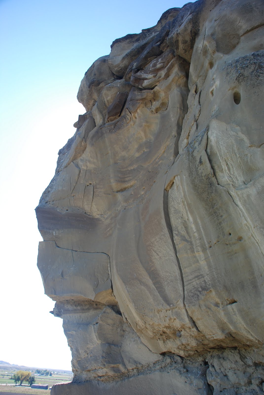

 Some observers suggest that this sandstone formation
resembles a mountain lion's head.
Pompey's Pillar was named Iishbiiammaache in the Crow language,
variously translated as "Where the Mountain Lion Lies,
"The Mountain Lion's Lodge," or "Where the Mountain Lion Preys."
by the Crow people.
It was a landmark for these proud people as well
as a productive hunting area for buffalo and small game.
The Indians would keep lookout on Pompey's Pillar
for buffalo and other
game coming down the Yellowstone River.
There was a bottleneck in the river
directly below the outcrop,
making it an excellent spot for hunting.
Some observers suggest that this sandstone formation
resembles a mountain lion's head.
Pompey's Pillar was named Iishbiiammaache in the Crow language,
variously translated as "Where the Mountain Lion Lies,
"The Mountain Lion's Lodge," or "Where the Mountain Lion Preys."
by the Crow people.
It was a landmark for these proud people as well
as a productive hunting area for buffalo and small game.
The Indians would keep lookout on Pompey's Pillar
for buffalo and other
game coming down the Yellowstone River.
There was a bottleneck in the river
directly below the outcrop,
making it an excellent spot for hunting.
 Mr. Hawthorne and I climbed to the top
of Pompey's Pillar
and the panoramic view is spectacular.
Mr. Hawthorne and I climbed to the top
of Pompey's Pillar
and the panoramic view is spectacular.


 A Crossroads of Events
The Yellowstone Valley at Pompey's Pillar
was a crossroads for travelers and wildlife
and a cavalry campsite and staging area.
The artist's rendering on this sign depicts the area
directly across the river as it may have looked in 1873
when Lt. Col. George Armstrong Custer
and men of the Yellowstone Expedition,
commanded by Col. David Stanley, camped there.
The troops protected engineers and surveyors
working on the Northern Pacific Line from Indian attacks.
The completed railroad would soon link
the rest of the country with the North Pacific coast.
A Crossroads of Events
The Yellowstone Valley at Pompey's Pillar
was a crossroads for travelers and wildlife
and a cavalry campsite and staging area.
The artist's rendering on this sign depicts the area
directly across the river as it may have looked in 1873
when Lt. Col. George Armstrong Custer
and men of the Yellowstone Expedition,
commanded by Col. David Stanley, camped there.
The troops protected engineers and surveyors
working on the Northern Pacific Line from Indian attacks.
The completed railroad would soon link
the rest of the country with the North Pacific coast.

 This rock I ascended and from its top
had a most extensive view in every direction....
after Satisfying my Self Sufficiently in this
delightful prospect of the extensive Country around,
and the emence hers of Buffalow, Elk, and wolves
in which it abounded, I decended and proceeded on...
Lewis & Clark Journals July 25, 1806
This rock I ascended and from its top
had a most extensive view in every direction....
after Satisfying my Self Sufficiently in this
delightful prospect of the extensive Country around,
and the emence hers of Buffalow, Elk, and wolves
in which it abounded, I decended and proceeded on...
Lewis & Clark Journals July 25, 1806


 Next up:
Pictograph Cave State Park.
Next up:
Pictograph Cave State Park.


No comments:
Post a Comment