Enjoy.
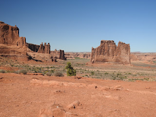
We're on our way to Arches National Park, in southeastern Utah, - a veritable "red-rock wonderland."
Hunter-gatherers migrated into this area about 10,000 years ago, finding quartz, chert, and chalcedony which were perfect for making stone tools. 2000 years ago, the nomadic hunters-gatherers settled in villages and began cultivating certain plants. These were the ancestral Puebloan and Fremont people. Although no dwellings have been found in Arches, rock inscription panels have been found. The ancestral Puebloans also left lithic remains, often overlooking watering holes, where they might have shaped tools while watching for game. After the Puebloans and Fremont peoples left the area, nomadic Shoshonean peoples, like the Utes and the Paiutes entered the area. They were here to meet the first Europeans in 1776. Some of the petroglyph panels show people on horseback, and horses were adopted by the Utes only after being introduced by the Spanish, which were the first Europeans to explore the Southwest, searching for routes across the deserts to their California missions. The first European settlement of southern Utah was Elk Mountain Mission, a colonization effort attempted by the Mormans in the 1850s in what is now Moab. The settlement was abandoned because of conflicts with the Utes. In the 1880s and 90s, Moab was settled permanently by farmers, ranchers, and prospectors. Word spread about the beauty of the red rock country around Moab and a local prospector, Alexander Ringhoffer, wrote the Rio Grande Western Railroad in 1923 to promote and publicize the area and gain support for creating a national park. President Hoover set aside Arches as a National Monument in 1929. Throughout the years, subsequent presidents modified the park size. It was enlarged by Franklin Roosevelt, diminished by Eisenhower, and then doubled in size by Lyndon Johnson. It became a National Park in 1971, under President Nixon.
The park lies atop an underground salt bed that is responsible for the arches, spires, balanced rocks, sandstone fins, and eroded monoliths. Thousands of feet thick in places, this salt bed was deposited across the Colorado Plateau 300 million years ago when a sea flowed into the region and eventually evaporated. Over millions of years, residue from floods, winds, and the oceans that came and went blanketed the salt bed. The debris was compressed as rock, at one time possibly a mile thick.
Salt under pressure is unstable, and the salt bed lying below Arches was no match for the weight of this thick cover of rock. The salt layer shifted, buckled, liquefied, and repositioned itself, thrusting the rock layers upward as domes, and whole sections fell into the cavities.
Faults deep in the Earth made the surface even more unstable.
Fault-caused vertical cracks later contributed to the development of arches. As the salt's subsurface shifting shaped the Earth, surface erosion stripped off younger rock layers. Except for isolated remnants, today's major formations are salmon-colored Entrada Sandstone, in which most arches form, and buff-colored Navajo Sandstone. They stand like a layer cake over most of the park. Over time water seeped into cracks, joints, and folds, Ice formed in the fissures, expanding and pressuring the rock, breaking off bits and pieces. Wind later cleaned out the loose particles, leaving a series of freestanding fins. Wind and water then attacked these fins until the cementing material in some gave way and chunks of rock tumbled out. Many of these damaged fins collapsed. Others, harder and better balanced, survived despite missing sections. These became the famous arches. Pothole arches are formed by chemical weathering as water collects in natural depressions and then eventually cuts through to the layer below.
This formation reminds me of the three wise men.
More to come...


No comments:
Post a Comment