
I told you,
Oregon has funky bridges.
Oregon has funky bridges.


We're driving down the coast
and I'm snapping pics out of my window.


Every now and then,
Mr. Hawthorne will pull over
and I'll get out and shoot.


More bridge funk.


You couldn't pay me to live on this spit.

It's scary!


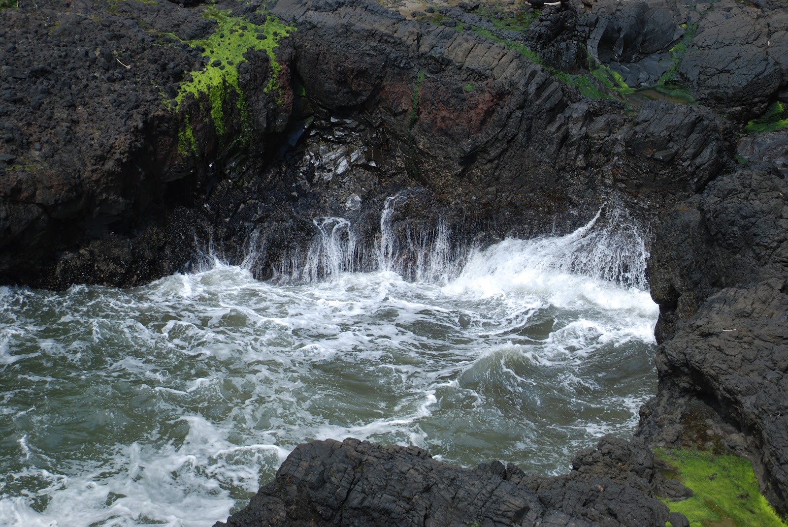
I could watch the waves crash over these rocks all day long.


This is Devil's Churn.
I'd love to see it at high tide
or during a storm.
It pulverizes, pounds, crashes, and smashes,
endlessly and relentlessly.
The Pacific Ocean careens into Devil's Churn.
The crescendo of waves explode in a riot of white froth
and then escapes back to the sea.
I'm walking the path down to Devil's Churn.
Poor Mr. Hawthorne will be staying in the truck.
What is wrong with the man?

I love seeing the various flora
I've never had the opportunity to see.

Ferns growing out of trees.


I'm on a mid-level here,
going down to Devil's Churn.
going down to Devil's Churn.

There's a person down there.


Check out the wave action.


Devil's Churn began as a small fracture -
a weak area in the ancient volcanic rock.
Thunderous waves have gnawed at the rock for eons,
eroding it away grain by grain, enlarging the crack into a chasm.
As you approach, you'll feel the power of the churn
like thunder in your bones,
and anticipate each collision of
wave and rock like bursting fireworks.
The sea never finishes its work ...
All along the coast, you'll see
chasms-in-the-making like the ones pictured here.
Some are only tiny fissures today -
reminders of the Devil's Churn's modest beginning.


I'm descending to Devil's Chasm.


Enjoy the scenery.


We left Devil's Chasm and traveled
to Cape Perpetua overlook -
800 feet above sea level and the highest point in Oregon.
From the crest, an observer can see
70 miles of Oregon coastline and as far as
37 miles out to sea on a clear day.

Traveling the Oregon Coast.
Cape Perpetua Scenic Area
Over the years, traveling this coastline has evolved
from a leisurely journey to a leisurely scenic drive.
In the 1800s, it would have taken you a month to get from Washington to California along the coast. Rocky headlands, wide coastal rivers, and turbulent surge channels presented one obstacle after another. Eventually, primitive foot trails were widened to accommodate wagons. By 1915, ferry service was available at most major river crossings.
World War I triggered a concern over national defense of the coast, and Congress approved construction of the Roosevelt Military Highway from Puget Sound to Mexico. By 1940, 394 miles of highway in Oregon were paved and bridges were in place, linking coastal communities.
Today, tourists can travel the length of the state in a leisurely one- or two-day drive.
By 1897, a crude 3-foot wide trail was cut around the face of Cape Perpetua.
Travel was still ticklish.
in howling winter storms;
mail carriers were know to crawl on their bellies,
hanging onto their horses' tails.
In 1914, the USDA Forest Service blasted
a narrow wagon road around the cape.

Here's the view from Cape Perpetua cliff
looking down on Devil's Chasm.


Here's an interesting little phenomenon -
Thor's Well at Cook's Chasm:

Just a ways south of Devil's Churn
is Cook's Chasm and Thor's Well, another fissure in the rock.
The incoming tide rushes into underwater caverns,
then compresses the air so there is a blowhole spouting
water and vapor into the air.

Again, high tide or during a winter storm
would be the time to see this spectacle at its best.


Notice the timber washed up on the rocks.


Thor's Well.


This is looking back up
to where we were on top.

Notice some idiots
are walking out to get a closer look at Thor's Well.


They wisely decided not to get any closer.


Oregon's bridges.
Up and down the Oregon Coast, bridge builders have spanned the chasms and coves with remarkable feats of artistic engineering.
In the 1800s, travelers faced innumerable obstacles when trekking along the coast. The route crossed inlets, chasms, and rivers - requiring determination and ingenuity of the engineers tasked with designing a coastal highway. To bridge the watery gaps, they incorporated some of the most innovative design techniques of the time.
The Oregon Department of Transportation has undertaken an effort to protect and restore some of the historic bridges through state-of-the-art preservation techniques. Those bridges that couldn't be saved have been replaced by new bridges designed to honor the classic look of their predecessors.


Lupine growing wild.


Scotch broom.


Bridgey funk.


This comment has been removed by the author.
ReplyDeleteGorgeous! I love the coast!
ReplyDeleteP.S. I left the other comment that was deleted. I'm moderating a friend's blog and I keep forgetting to log out! Darn it!