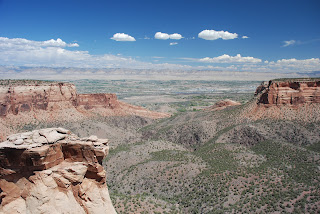
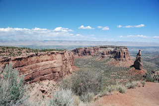
Welcome to Part 3 of Colorado National Monument.
The rocks that make up this landscape formed in environments that are very similar to ones we can observe on the earth's surface today, as well as ones that occur beneath the surface where tectonic plates collide to form mountain ranges.
The top layer is referred to as the Kayenta Formation. It is a sandstone layer that is more resistant to erosion than many of the other sedimentary rocks in the park. The Kayenta Formation was deposited by a high-energy braided river system similar to the Rio Grande River in New Mexico.
The next lower layer, The Wingate Formation, is a tan sandstone layer whose sweeping tilted layers tell us that this rock was deposited in a desert environment where wind-swept sands accumulated and were buried. An environment like this can be found in the modern Sahara Desert of North Africa.
The third, and lowest layer is the Chinle Formation. This layer is primarily a reddish-brown mudstone that likely was deposited in densely-vegetated floodplains or mudflats with small ponds and streams. This environment is similar to the coastal environments in South America and Africa.
Precambrian metamorphic rocks, dark schists, and light pegmatites are the extremely erosion-resistant basement rocks found in the bottom of the Monument's canyons. These rocks began as sediments that were later deformed in mountain building processes. They were deposited, buried, heated, squeezed, uplifted, and planed off by erosion - all before the sedimentary rocks of the Monument were deposited. Today, rocks like these are being formed and then deformed where tectonic plates converge. An example is along the western margin of South America.
Independence Monument, is the largest free-standing monolith
in the park, rising 450 feet from the canyon floor.
It was once part of a massive rock wall
that separated Monument and Wedding canyons.
As the forces of erosion gradually enlarged these canyons,
the dividing wall was weakened and narrowed
and Independence Monument was carved out
over millions of years.
Weathering and erosion proceeded more rapidly
in places where the rock was most vulnerable.
Eventually the wall was breached and parts of it collapsed.
Today, a remnant of the once solid rock wall survives
as Independence Monument.
This too will eventually succumb
to the ravages of time and weather.
Now, Independence Monument is a favorite for rock-climbers.
Damn.
I left my pitons at home.
"Otto's Route" is considered a classic tower climb and is
still followed every year by hundreds of recreational climbers. After
ascending most of the route in Wingate Sandstone, the final push to the
top includes a precarious backward-leaning climb out from under the
caprock of Kayenta Formation to the top of the monolith. Initiated by
John Otto, the tradition of raising the American Flag atop Independence
Monument on July 4th continues today.
With his climbing partner Rae Kennedy, and photographer Whipple Chester, John Otto became the first person to summit Independence Monument.
Otto had been in the area five years by then. When he arrived in the Grand Valley he had immediately fallen in love with the canyon landscape and had been working tirelessly to rally support for protecting the area as a notional park. A month earlier, on May 24, 1911, Otto's goal was fulfilled when U.S. President William H. Taft established Colorado National Monument. What better way to celebrate than to climb Independence Monument?
The Shape of Independence
Does the shape of Independence Monument help tell the park's erosional story? It depends on your viewpoint. From here the monolith appears to be shaped like a tower, but the sideview shows that it is the remaining piece of a rock wall between
Monument Canyon and Wedding Canyon.
Monument Canyon and Wedding Canyon.
About two million years ago ...
Floods and streams in Wedding Canyon and Monument Canyon carved into the highlands of Colorado National Monument, but these two separate drainages were divided by a high wall of rock. If you were here back then, you likely could have walked across the top of this wall from here to the far promontory which would later become known as "The Island."
The flowing streams and floodwaters in the two canyons carved back and forth between the canyon walls. Freezing and melting, landslides and floods wore down parts of the wall between the canyons, shaping what would become Independence Monument.
Today...
Independence Monument is largely protected from flooding waters that occur in drainages carved into hard Precambrian metamorphic rocks in the canyon floors. However the sedimentary rocks that make up Independence Monument continue to be slowly eroded by seasonal freezing and melting and by rain, snow, and wind.
Tragedies on Rim Rock Drive
Twenty-three mile Rim Rock Drive was built almost entirely by using picks, shovels, and sheer muscle to remove massive rock and debris. The engineering skill of the workers can be seen today in the tunnels and stonework. With construction came a high cost in human life however. Nine men were killed in a single accident at Half-Tunnel when tons of rock suddenly fell from a cliff into their work area. Two other men died in separate accidents.
With great appreciation, Colorado National Monument
remembers these men and their families.
With great appreciation, Colorado National Monument
remembers these men and their families.
IN MEMORIUM
Frank Winters
Harley Beeson
Virgil Minor
William Liddle
Leo Adams
Ed Carmichael
Robert Fuller
John D. Rupe
Clyde Van Loan
W.L. Wilson
Robert Newton "Buster" Moreland, Jr.
The use of explosives was commonplace
during the construction of Rim Rock Drive. The Half-Tunnel accident
occurred on December 13, 1933. In this active construction and blasting
zone, workers returned to clear debris 20 minutes after a blast had
been detonated. The overhanging rock roof suddenly collapsed, crushing
men beneath the rubble. The photograph to the right shows a typical
blasting event at the site.
The photograph below was taken after the accident.
The photograph below was taken after the accident.
Notice closely above in the second rock formation
on the left in the background.
You will see Windows Rock.
This is a shot of Windows Rock closer up.
Windows Rock is a hole carved out of a crack
in a stone wall by thousands of years of relentless erosion.
This is Balanced Rock.
It's a 6oo-ton boulder perched atop a pedestal.
Of course Rosie wanted to get out
and push the rock over.
Mr. Hawthorne restrained me.
Stayed tune for my videos
of Colorado National Monument.
of Colorado National Monument.
Next, the Hawthornes head for Wyoming.


No comments:
Post a Comment